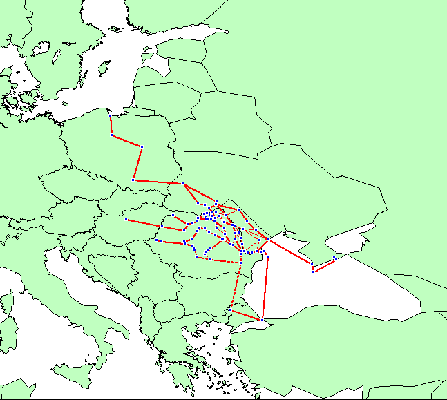
Land and maritime trade routes of Moldavia and Transylvania 1450-1500 CE.
http://www.ciolek.com/OWTRAD/DATA/tmcMDm1470.html
Ciolek, T. Matthew. 2007. Georeferenced data set (Series 1 - Routes):
Land and maritime trade routes of Moldavia and Transylvania 1450-1500
CE. OWTRAD Dromographic Digital Data Archives (ODDDA). Old World
Trade Routes (OWTRAD) Project. Canberra: www.ciolek.com - Asia
Pacific Research Online.
www.ciolek.com/OWTRAD/DATA/tmcMDm1470.html
115 data points defining medieval trade routes connecting the Baltic
and Black Sea.
This document comprises a georeferenced data set belonging to the Old
World Trade Routes (OWTRAD) project. It can be used for historical
research (e.g. validation of some set of facts); analyses of
distances/ travel times/ modes of travel/ cargo moved along
particular transportation corridors; construction of an electronic
map, or GIS model of the movement/ transport/ communication circuits
in a given area and time-period.
Source: Racovitza, Carmen. 2005. Stefan cel Mare: Drum si Stat
[Steven the Great: Road and State] (esp. an untitled draft map of
Baltic-Black Sea trade route of Eastern Europe, p. 70; and map 2,
'Moldova Medievala', p. 70-71). National Geographic Romania. June
2005. pp. 58-85.
Please note that the above details were correct on the day this post was published. To suggest an update, please email the site's editor at tmciolek@ciolek.com
posted by tmciolek at 3:45 PM
![]()
![]()


<< Home